


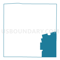
Voting District 0013, Scurry County, Texas
About
Outline

Summary
| Unique Area Identifier | 676697 |
| Name | Voting District 0013 |
| County | Scurry County |
| State | Texas |
| Area (square miles) | 112.69 |
| Land Area (square miles) | 112.63 |
| Water Area (square miles) | 0.06 |
| % of Land Area | 99.94 |
| % of Water Area | 0.06 |
| Latitude of the Internal Point | 32.62703240 |
| Longtitude of the Internal Point | -100.73101280 |
Maps


Graphs
Select a template below for downloading or customizing gragh for Voting District 0013, Scurry County, Texas


Neighbors
Neighoring Voting District (by Name) Neighboring Voting District on the Map
- Voting District 0004, Mitchell County, TX
- Voting District 0006, Nolan County, TX
- Voting District 0011, Scurry County, TX
- Voting District 0012, Scurry County, TX
- Voting District 0013, Fisher County, TX
- Voting District 0014, Scurry County, TX
- Voting District 0017, Fisher County, TX
Top 10 Neighboring County Subdivision (by Population) Neighboring County Subdivision on the Map
- Snyder CCD, Scurry County, TX (14,921)
- Colorado City CCD, Mitchell County, TX (7,333)
- Roscoe CCD, Nolan County, TX (2,049)
- Rotan CCD, Fisher County, TX (1,968)
- Roby CCD, Fisher County, TX (1,785)
- Loraine CCD, Mitchell County, TX (1,097)
- Hermleigh CCD, Scurry County, TX (779)
Top 10 Neighboring Place (by Population) Neighboring Place on the Map
Top 10 Neighboring Unified School District (by Population) Neighboring Unified School District on the Map
- Snyder Independent School District, TX (15,627)
- Colorado Independent School District, TX (7,498)
- Roscoe Independent School District, TX (1,866)
- Roby Consolidated Independent School District, TX (1,430)
- Loraine Independent School District, TX (997)
- Hermleigh Independent School District, TX (751)
Top 10 Neighboring State Legislative District Lower Chamber (by Population) Neighboring State Legislative District Lower Chamber on the Map
- State House District 71, TX (146,722)
- State House District 85, TX (143,267)
- State House District 72, TX (139,868)
Top 10 Neighboring State Legislative District Upper Chamber (by Population) Neighboring State Legislative District Upper Chamber on the Map
Top 10 Neighboring 111th Congressional District (by Population) Neighboring 111th Congressional District on the Map
Top 10 Neighboring Census Tract (by Population) Neighboring Census Tract on the Map
- Census Tract 9502, Mitchell County, TX (7,333)
- Census Tract 9506, Scurry County, TX (5,056)
- Census Tract 9501, Scurry County, TX (4,849)
- Census Tract 9505, Nolan County, TX (2,736)
- Census Tract 9504, Fisher County, TX (2,189)
- Census Tract 9504, Mitchell County, TX (2,070)
- Census Tract 9503, Fisher County, TX (1,785)
Top 10 Neighboring 5-Digit ZIP Code Tabulation Area (by Population) Neighboring 5-Digit ZIP Code Tabulation Area on the Map
- 79549, TX (15,652)
- 79512, TX (8,197)
- 79546, TX (2,006)
- 79545, TX (1,788)
- 79526, TX (979)
- 79532, TX (940)